

 by Tim Doherty/photos by the author except as noted
“I started on a train that took people to work,” remarked the Medford, Mass.-born travel writer Paul Theroux, as he embarked on the Orange Line to begin a long train journey from Boston to the tip of South America. Boarding at the newly opened Wellington station in the late 1970s, Theroux joined the 100,000 other daily Orange Line passengers on a line midway through a modernization project that would see both ends of the line entirely replaced.
The Massachusetts Bay Transportation Authority (MBTA), or “the T,” as it is more commonly known by riders, fans, detractors, and the public at large in Massachusetts, is the sixth-largest transit system in the U.S. Serving 171 cities and towns across eastern Massachusetts and operating all modes of service from streetcars to ferry boats, MBTA is complex, old, and currently in a long period of crisis.
Shortly after its creation, MBTA commissioned a new marketing and design system to bring unity and simplicity to the information it gave passengers. The use of colors and graphics according to the standards developed in 1965–1966 remains in place today. The bold red, blue, green, orange, yellow, and purple represent the four rapid transit lines, the bus network, and the commuter rail system. How did the Orange Line become orange? The color looked good on the map compared to the other lines associated with distinct locations — red for Harvard University, blue for the ocean bordering the line to Wonderland, and green for the Emerald Necklace of public parks that runs through Boston and Brookline. The Cambridge Seven architecture firms that developed the design guidelines would go on to design multiple MBTA projects, including the Orange Line’s new Forest Hills station.
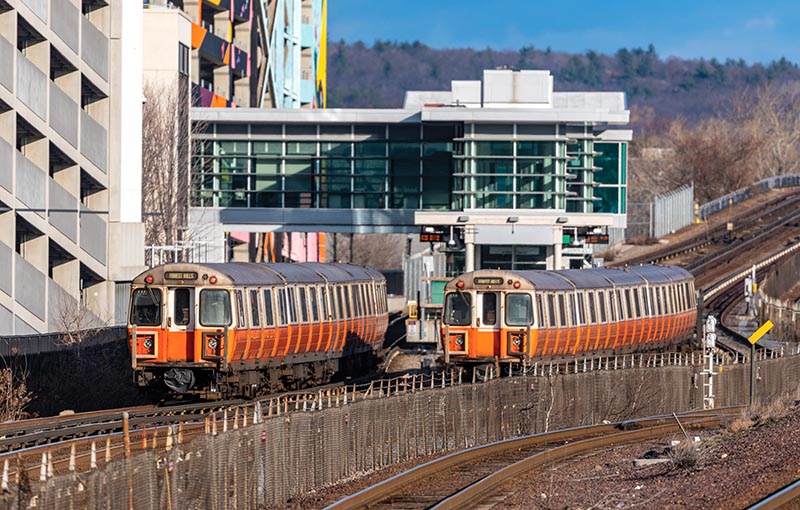
ABOVE: A pair of Orange Line trains passes Assembly station on December 15, 2019. Opened in 2014, Assembly was the first new MBTA rapid transit station to open since 1987. The infill station has successfully leveraged the massive mixed-use redevelopment of the adjacent Assembly Square and Assembly Row complexes built on the site of a former Ford plant in Somerville, Mass.
The Main Line Elevated
When MBTA was created in August 1964, the Main Line Elevated was eight miles long with 15 stations, including five in downtown Boston. Opened in 1901, the northern end came above ground on the Charlestown Elevated at the Canal Street Incline between Haymarket and North Station and continued to Everett, just north of Boston via Sullivan Square, and Charlestown in Boston. The tunnel under Washington Street, with its five stations, connected the northern end with the Washington Street Elevated, which continued over the street all the way to Forest Hills. On the present Orange Line, both the northern and southern ends have changed dramatically, rebuilt in a flurry of mass transportation construction that began in the 1960s and ended in the 1980s.
Right before the turn of the 20th century, the congestion caused by the large number of streetcars coming into the center of the city spurred the construction of the subways and elevated lines by the Boston Transit Commission, financed with city and state funds. Once completed, these lines were leased back to Boston Elevated Railway for operation. The core of the MBTA’s modern rapid transit lines was constructed between 1897 and 1927, with the last section opening just before World War II.

ABOVE: A Forest Hills-bound Orange Line train is just beyond Jackson Square station on the Southwest Corridor with the three parallel railroad tracks in the foreground on November 2, 2023. The 154-car order of CRRC-MA No. 14 cars should allow peak headways of one train every four minutes.
As the first subway along Tremont Street was being constructed, work began on the Main Line Elevated. Seeking economy, the Boston Transit Commission constructed elevated lines rather than underground subways in the interest of cost savings. Opening on June 10, 1901, between Sullivan Square and Dudley station, the elevated lines were true rapid transit lines with limited stations, electric multiple-unit (EMU) equipment, and a dedicated right-of-way that provided much faster travel times than did streetcars in city traffic. The Main Line initially shared a portion of the Tremont Subway until the tunnel under Washington Street opened in 1908. The parallel Atlantic Avenue Elevated opened first in 1901, connecting North and South stations as well as the many steamship and ferryboat docks along Atlantic Avenue. Less than successful during its operation, the Atlantic Avenue Elevated ran its last train on September 30, 1938, and is the only Boston rapid transit line to be abandoned, dismantled, and sold for scrap.
When the elevated lines opened, the surface streetcar operation changed dramatically, as all these lines now terminated at various elevated terminals instead of running through downtown. The long-haul radial streetcar lines that once went into the city were rearranged and connected to the rapid transit lines that now provided long-haul service to the center of Boston. Operating on surface streets, these routes now collected passengers from their neighborhoods and transferred them to the rapid transit lines. Boston was one of the earliest systems to coordinate surface operations with rapid transit through transfers. The extensive and complex transfer systems from surface lines to outlying rapid transit stations like Harvard, Sullivan, Lechmere, Wonderland, Ashmont, and Forest Hills remain today.

ABOVE: In 1974, MBTA purchased Boston & Maine’s Western Route to rebuild the Orange Line from Sullivan Square to Oak Grove, and replaced Draw 8 over the Mystic River with the Edward Dana Bridge. On July 16, 2008, B&M successor Pan Am Railways’ Peabody local is crossing Draw 7 on the Eastern Route as an Oak Grove-bound Orange Line train crosses the Dana Bridge against the backdrop of Boston.
The postwar economy increased car ownership, and G.I. Bill incentives supercharged suburban housing beyond the reach of what was then the Metropolitan Transportation Authority. Responding to the challenge of declining ridership, MTA converted surface routes to buses, cut headways, and deferred maintenance. By 1969, the total passenger volume was reduced to 153 million trips per year, down 24 percent from 1960 and 65 percent from the postwar high of 1946. More surprisingly, it was only 11 percent above the total in 1891.
By increasing the headways — the time intervals between trains, buses, or streetcars passing the same points on the same routes — MTA repeatedly sought to limit costs but also drove away passengers. Headway increases saved labor costs by requiring fewer vehicles and operators rather than cutting routes completely. Over time, these changes compounded the impacts on passengers, as the efficiency of connecting to the rapid transit system decreased, causing longer wait times and risking missed connections. Similar challenges to the transfer system occurred more recently, as widespread slow orders from infrastructure defects caused longer travel times on the combined rapid transit system and bus feeders, slowing the MBTA’s post-pandemic ridership recovery.

ABOVE: Built during the Southwest Corridor project and opened in 1987, modern Back Bay station has three sets of tracks with the Orange Line in the middle, the MBTA Worcester Line (Boston & Albany) main line to the north, and Northeast Corridor with Amtrak and the MBTA commuter rail to the south.
By 1960, neither Boston’s rapid transit lines nor the surface lines transferring to them reached far enough to catch the ever-increasing number of commuters now traveling into Boston in their cars. The previously highly efficient system now struggled to increase suburban ridership while limiting costs. Recognizing the need to achieve greater market reach, the cover of MTA’s 1963 annual report (which would be its last) asked, “Breakthrough to suburbia… When?”