

 by Scott Lothes/photos by the author
It’s June 2002, and I’m driving west in north-central Oregon on State Route 216 through the beige rolling fields of the Columbia-Deschutes Plateau. The afternoon sky is cloudless and so blue it’s a shock to my eastern sensibilities. Mount Hood punctuates the western horizon, glistening in snow that will linger into August. I’m on a big western road trip after graduating from college, and I’ve just left the bustling main lines of the Columbia Gorge to explore a lonely railroad. I’d read about the Oregon Trunk a year earlier in a two-part article by Greg Brown and Brian Rutherford in CTC Board magazine. Both authors extolled the line’s remarkable scenery and lamented its infrequent trains, cautioning readers that long waits and frustration were common.
Where the sun-baked pavement began to pitch forward and plunge into the Deschutes Canyon, my radio scanner picked up the best possible transmission. The dispatcher was setting up a meet at a siding called Oakbrook. I’d have just enough time to get to the top of Tunnel 2, a signature location where the tracks cross the river twice on dizzying deck girder bridges. Within the hour I’d photographed a train on each bridge in the warm sunlight of late afternoon, a BNSF mixed freight coming north and Union Pacific’s Bend Local (abolished less than two years later) going south.
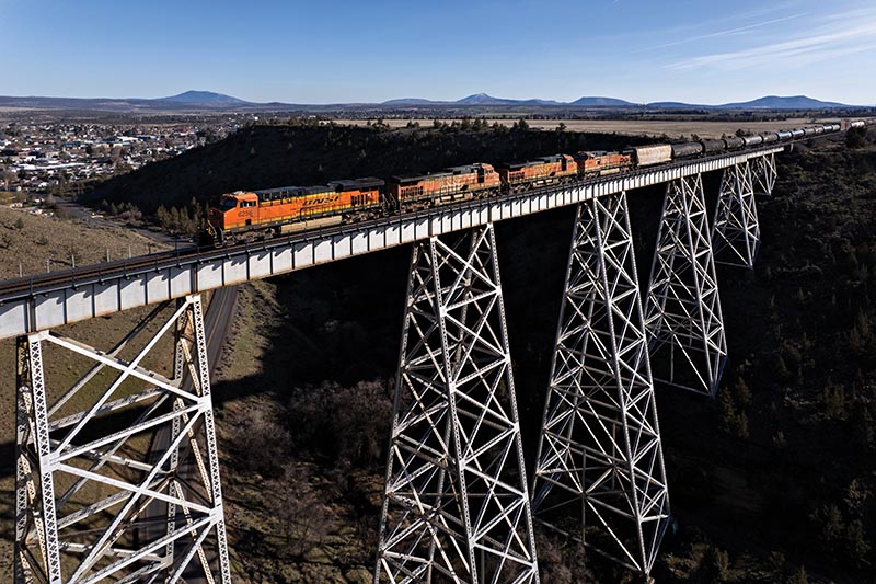
ABOVE: A Barstow–Pasco train soars over Willow Creek Trestle at Madras in a drone view as the afternoon shadows grow long on March 17, 2024.
As I drove down the Bureau of Land Management’s gravel access road, I remember thinking, “What’s so hard about photographing the Oregon Trunk?”
After a pleasant night by the river at the Trout Creek campground, I spent almost the entire next day along the railroad… and saw no trains.
Background
The Oregon Trunk runs from the Columbia River at Wishram, Wash., up the Deschutes River to Bend, Ore. It’s the consolidation of two railroads built in the last great competition between James J. Hill and E.H. Harriman in the early 20th century (a story well-told by Leon Speroff in his book The Deschutes River Railroad War).

ABOVE: The first half of an empty grain train out of Modesto, Calif., lights up Trout Creek Canyon in a 20-minute exposure from 3:00am on May 11, 2011. The glow on the low clouds comes from Warm Springs, 10 miles to the west.
The Oregon Trunk eventually became part of BNSF’s north-south link between the Pacific Northwest and Southern California, known as the Inside Gateway. It’s a hodgepodge of routes that includes three long stretches of Union Pacific trackage rights — some granted as a condition of UP’s 1996 merger with Southern Pacific. UP’s I-5 Corridor is the principal north-south line on the West Coast, and the Inside Gateway provides an alternative — albeit about 200 miles longer.
It’s 152 miles from Wishram to Bend with a climb of nearly 3,500 feet. Much of that happens near the middle, up the 1.5 percent grade out of the canyon from South Junction to Madras, a helper district in the steam era. North of there, the tracks curve along the swift and cold Deschutes; to the south, trains run fast across the irrigated fields of the high plateau, crossing two massive bridges, with the shimmering peaks of the Cascades standing always in the distance.

ABOVE: A 100-car unit train carrying canola meal crosses Celilo Bridge over the Columbia River from Wishram, Wash., into Oregon on the evening of July 9, 2011, to begin its trek south on the Oregon Trunk. The train came out of Canada and has a mix of eight CN and BNSF locomotives, arranged 3x3x2.
The railroad is single-track with sidings, many of them relatively short. Most of the tonnage moves south (distributed power is common); BNSF will run non-clearing southbounds, but northbounds have to fit the sidings. Until 2018, this was track warrant territory with automatic block signals and hand-thrown switches.
The oddity of a place name like South Junction and its nearby counterpart, North Junction — with no sign of any connecting lines — is a legacy of those two competing railroads. The stretch between them is so rugged that the competitors reluctantly agreed to share a single track. North Junction is where their lines came together, and South Junction is where they split back apart. Consolidation came in two phases, completed in 1935. The Hill route comprises most of what remains, but the Harriman line was superior from South Junction to Metolius. To this day, Union Pacific owns those 24 miles and leases them to BNSF.

TOP LEFT: Drone technology offered new perspectives when the author returned to the Oregon Trunk in 2024 following an 11-year absence. Here, a Vancouver, Wash.–Fresno, Calif., train crosses the Crooked River Bridge at Terrebonne late in the afternoon of March 18.
For most of the BNSF era, the primary trains have been two pairs of daily manifests, one for Pasco in eastern Washington and another for western Washington, typically Vancouver or Everett. Their terminal on the other end is usually Barstow but can also be Bakersfield, Fresno, or Riverbank. There used to be two locals based out of Bend, a morning job that worked to Redmond and an afternoon job that went to Madras. In the past few years, they’ve been consolidated into one job, currently on duty at 6:00am Monday through Friday. It can still go as far north as Madras but sometimes turns back at Redmond or Prineville Junction.
Further traffic includes unit trains and baretable trains of empty intermodal equipment. While many days have no extra trains, I’ve occasionally seen as many as three in a day. Loaded unit trains going south include grain from BNSF-served elevators along its northern transcontinental route, canola meal out of Canada, and oil from the Bakken field. Unit trains often employ distributed power and are frequently too long for the sidings, with the empty cars sometimes returning north in two sections…