
 by Justin Franz/photos as noted
In June 2020, I set out on a seven-day railfan trip across the Intermountain West, covering a number of railroad operations in Montana, Idaho, Wyoming, Utah, and Colorado. It was my first major trip since the start of the pandemic and the primary goal was to officiate a friend’s wedding aboard Heber Valley Railroad (albeit a much, much smaller wedding than originally anticipated, consisting of the bride and groom and a few close friends). Of course, a smaller wedding wasn’t the only side effect of a global pandemic. Most of the events that fill our weekends and evenings had been canceled, meaning there was a lot more time to sit around the house, surf the internet, and plan. As my departure approached, I spent a lot of time planning. Perhaps too much time.
More Tools Than Ever
A decade or two ago, planning for a railfan trip was pretty straightforward — you’d dig out your DeLorme map for whatever state or states you were visiting, try and find some timetables for your target railroad, and maybe read a story or two in the railfan press covering what you hoped to see. One time, as Dad and I were departing for a road trip to shoot CSX on Sand Patch, the mail carrier arrived with a new issue of Railpace Newsmagazine just as we were getting ready to pull out of the driveway. That issue featured one of its iconic “Chaser Guides,” this time to Mountain Subdivision west of Cumberland, Md. That happy little coincidence changed our entire trip for the good!
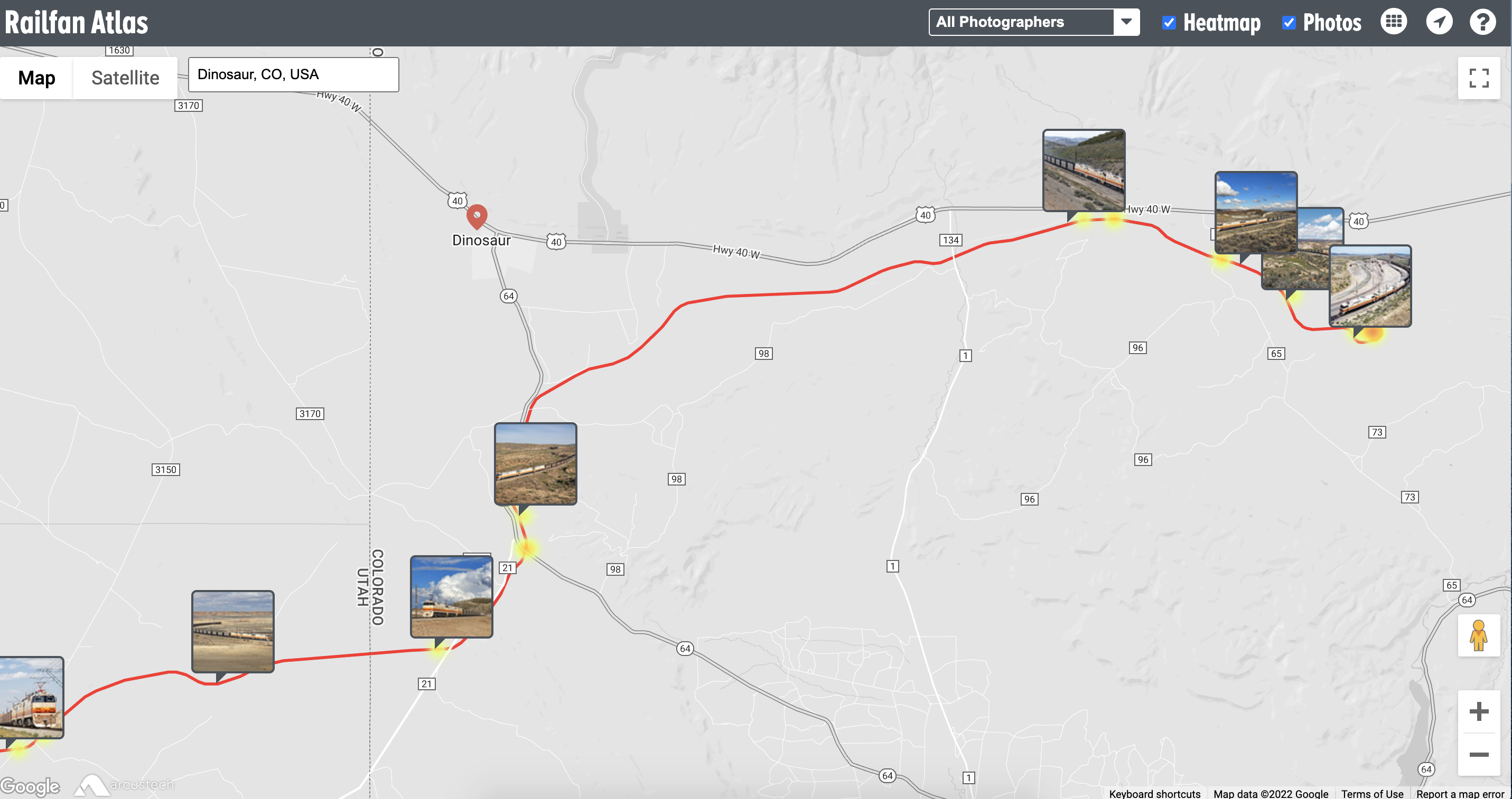
RailfanAtlas.com by Nick Benson might be one of the best tools online for railfans planning a trip.
But today there are countless tools for traveling railfans. One of the best in recent years is RailfanAtlas.com, run by Nick Benson. RailfanAtlas looks a lot like any other online map, but it’s connected with the Flickr database. A photographer can opt to add their image (and its tagged geolocation) to the atlas by adding it to the RailfanAtlas group on Flickr.com. Then that image will pop up on the map, which includes most rail lines (past and present) so you can get an idea of what the railroad looks like ahead of time and what shots are available. Of the many online tools available to us today, RailfanAtlas might be one of the best.
Then there’s Google Earth. Gone are the days of a DeLorme map made up of simple rail lines and highways. Now you can zoom into the landscape and see the topography and more. If your destination is along a highway, you can even check out the street view. In recent years, Google Earth has added a 3D option that lets you check out the landscape at an angle, which is particularly helpful if you’re looking for potential drone angles (although there are limitations to that because the Google view tends to be much, much higher than the legal 400 feet you can fly). Using Google Earth, you can scope out a specific piece of railroad ahead of time and pinpoint potential locations that might not be on the abovementioned RailfanAtlas. The railfans of a generation or two ago would have lost their minds with this type of information.
Another great tool is sun angle maps, one of the most popular being SunCalc.net, although it’s been a few years since it has been updated. I personally like the app PhotoPills, which can be downloaded for $10.99 (as of summer 2022) on an iPhone and other smartphones. This app includes a sun angle planner, plus a star trail calculator, a star planner (useful for figuring out where the Milky Way might be at a particular location or time), and a whole bunch of other uses I haven’t even discovered yet. For railfanning, though, that sun angle planner is the best. You can drop a point on the map and figure out exactly when the light will be right for a certain location (be it if you’re following the old “sun behind your back” rule or aiming to shoot glint or backlight). I have found this tool most useful for local locations that I visit often and know well; if I know there’s a train coming at a certain time of day that I want to shoot, I cue up the planner and figure out exactly where I’d want to go or confirm a notion about the lighting that I already have in my head.
The ‘Perfect’ Plan
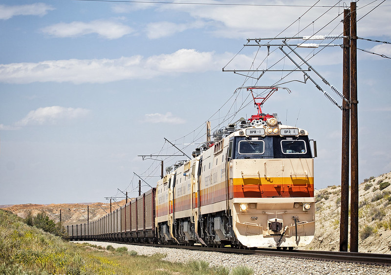
As June 2020 approached, I deployed all the above tools in planning my trip south to Utah. I timed my departure from home to get to Dillon, Mont., in the mid-afternoon, in time to chase Union Pacific’s southbound Silver Bow, Mont., to Pocatello, Idaho, road freight, before heading south after sundown to Idaho Falls for the night. On day two, I’d chase the southbound local out of Idaho Falls down to Pocatello, past a stretch of old UP signals, before ditching that when the midday light got bad and heading for Heber Valley to shoot that railroad’s newly acquired ex-Pan Am Geeps on the afternoon excursion out of Heber City. Using Google Earth, RailfanAtlas, and PhotoPills, I determined that the light would be perfect on a small wooden trestle about halfway up the line. I would end the day in Evanston, Wyo., to be ready for a day on the UP main line just west of there in Echo Canyon. One of my primary goals was the classic shot just east of Echo passing the impressive red rock cliffs. Once that photo was in the bag, I’d head back west to the Salt Lake Valley — specifically Jordan Narrows — for an afternoon shot of Utah Railway’s RUT611, which at the time was regularly sporting a pair of gray and red SD50S locomotives; PhotoPills confirmed that the light would be perfect for the afternoon northbound. After checking that shot off the list, I’d go east for a day-and-a-half on the isolated electric Deseret Power Railroad. Deseret consistently runs in the morning and afternoon, meaning it’s pretty easy to scope out shots ahead of time. After shooting the morning train on day five of the trip, I’d head back west to Heber City for the wedding and to have another chance at that bridge shot on the Heber Valley (just in case it was cloudy on the first day or the railroad was using the other ex-Pan Am Geep). Then it’d be time for the wedding before heading home the next day.
That was the plan as I departed my home on day one and, incredibly, that’s exactly how the trip played out. Even a derailment on UP near Rock Springs that basically shut down the main line while I was there didn’t prevent me from getting the one morning eastbound I needed for that Echo Canyon shot. And it turns out it was a good thing I added in that second attempt on Heber Valley because the first day was cloudy and the second day featured a different locomotive (my favorite, the Maine Central-painted 52). Otherwise, the sun shone and the trains ran almost exactly as expected. The trip had been meticulously planned down to the hour and, incredibly, it worked out as planned.
So you would think, as I drove home in the rain, I would be ecstatic with the results of all my planning. But I wasn’t. Even after I edited the images, something seemed lacking about them. I just couldn’t put my finger on it…
A few weeks after embarking on a meticulously planned trip to Colorado and Utah, Associate Editor Justin Franz took a much more relaxed trip to eastern Washington. Photo by Justin Franz.
Another Trip, a Different Method
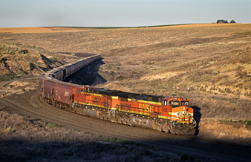
A month or so later, the urge to go somewhere — anywhere — bit again. It was the end of July, northwest Montana was full of tourists, smoke from local wildfires was hanging over everything, and my wife had to work over the weekend. I didn’t know what I was going to do with those two days but I knew I was getting out of town. I happened to be texting with my friend and fellow railfan James House. He, too, was feeling the doldrums of summer and was also interested in getting out of town. So a few days later, I was up before dawn and drove about two hours south to Missoula to meet with James and head west. Exactly where west was unknown. As we got on Interstate 90, we discussed our options. The idea that had emerged earlier in the week was BNSF Railway’s Columbia River Subdivision, home to the Trinidad Loop. While I had ridden Amtrak over the line (at night) and James had recently driven through the area, we didn’t know much more about the railroad besides what we had seen in books and magazines in the past. We figured we’d arrive there at midday, scope out some shots while the light was bad, and then be in position for whatever BNSF sent us in the evening. We didn’t have any specific shots in mind, we’d just see what we’d find.
That plan — however relaxed — fell apart almost as soon as we made the turn toward Trinidad. A wildfire had sparked west of town, sending a plume of smoke high into the sky. It seemed unlikely that it would be stopping anytime soon and (using that PhotoPills app I mentioned earlier) we confirmed that the sun would be setting right behind the plume. Diffused, smoky light? No thanks. We needed a Plan B.
While a haze was hanging over much of eastern Washington, it looked as if there wasn’t going to be a thick plume of smoke hanging over Providence Hill, about an hour east of Trinidad and home to BNSF’s much busier Lakeside Subdivision. Like Trinidad, I didn’t know much about the Lakeside Subdivision; I had driven through the area on the interstate (within view of the tracks at times), had ridden Amtrak on it (again at night), and had seen a few photos in books and magazines. James, on the other hand, had at least gotten off the interstate, driven the route once or twice before, and taken a few photos — but he hadn’t dedicated much effort beyond that. Let’s see what we find down there, we mused, as we turned the car back east.
We got trackside just as an afternoon fleet of trains began to attack the hill. While I had seen a few photos of the railroad before, this was all new territory and it was fun to discover what was around the next bend. We ended the day in some coulees outside of Connell and found an S-curve that was perfect for a morning eastbound. We decided to come back the next morning with the hope of shooting some trains there. The next day, we did just that.
Different Strokes for Different Folks
Looking back at the images from both of those trips, I’m pretty happy with them, but I certainly had a lot more fun creating the ones on Providence Hill. One of the reasons I got into railfanning was having an excuse to explore new places and you get robbed of that a little when you overplan a trip (drive here, get out, take photo at this specific hour, get back in car, drive to next spot…). That first trip felt almost robotic. There was no sense of discovery. The resulting images weren’t as satisfying because I had envisioned them before I even left home.
That’s not to say I don’t do any planning now before a trip. I like to tour an area online before going somewhere to get an idea of what’s possible — and to be able to take advantage of good photo opportunities when they present themselves — but I don’t try to plan an itinerary shot by shot. In a perfect world, I’ll scope out a place a little online and then get there and do some scoping on the ground before taking full advantage of what I find over the course of an afternoon or a few days. With that method, I hope to get a few good shots to take home and enjoy that sense of discovery that many of us relish when traveling.