 By Tim Doherty/photos by the author
Boston is an ever-changing city. You pass by a place you haven’t visited in a few months, and you discover that a new skyline has sprouted from the ground. In contrast, the transit system seems frozen in time. The steps in the Downtown Crossing station that once led to Filene’s Basement remain, but the consumer touchstone of New England value was replaced long ago by a modern skyscraper. Over the years, Boston’s transit system has struggled to keep up with these quick transformations.
As Boston aspires to be (and generally is) a world-class city, the concentration, intersection, and interdependence of educational institutions, technology, life sciences, and finance allow the region to punch much higher than its population suggests. The rapidly growing technology and life sciences hubs around Kendall Square and Massachusetts Institute of Technology in Cambridge are matched by similar growth in the Boston Seaport district — which literally emerged from parking lots over the past 15 years. By location and proximity, the Red Line runs right through the center as it connects Harvard, MIT, and the technology hub of Kendall to Massachusetts General Hospital, downtown Boston, South Station, and the Seaport business district.
Massachusetts Bay Transportation Authority (MBTA, or “the T”) is the sixth-largest transit system in the U.S., serving 171 cities and towns across eastern Massachusetts and operating all modes of service including bus, rail, and ferry boats. As recently as 10 years ago, the Red Line carried just as many, or even more, people into Boston than Interstate 93, the main north-south highway through the city that includes the tunnel created by the infamous “Big Dig” project. Riding the Red Line at that time could be interesting at best; open seats were rare, complete crush loading was common, and cars became more intimate than commuters bargained for.
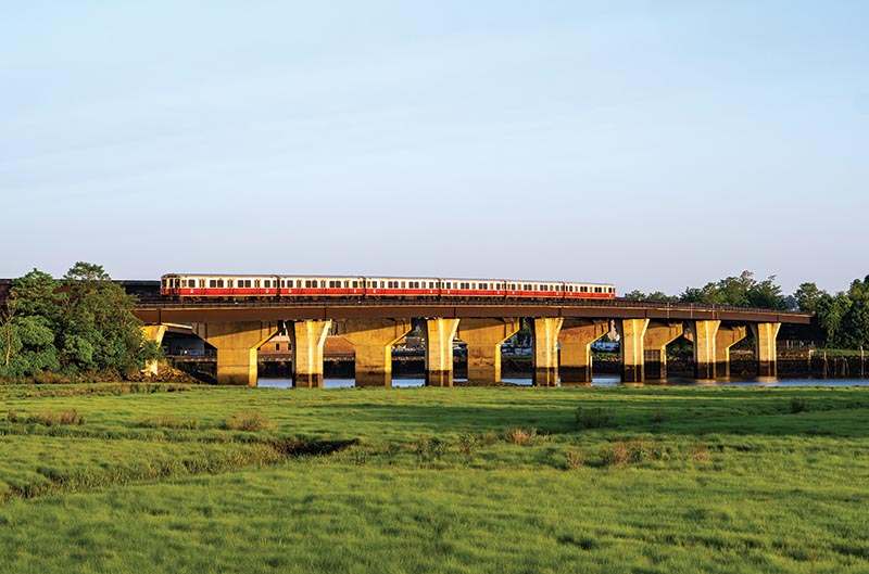
ABOVE: The new Neponset River Bridge was the first element of the South Shore extension to begin construction in 1966 after MBTA purchased the right-of-way from the bankrupt New Haven Railroad. A six-car train of Series 2 cars heads south across the river to Quincy and Braintree on June 11, 2025.
Even before the pandemic flatlined transit ridership worldwide, Boston’s Red Line was stumbling. An exceptionally snowy winter in 2015 (locally known as “Snowmageddon”) shut down the Red Line south of downtown, laying bare the critical condition of the transit system caused, in large part, by a long period of underinvestment. Further challenges, including conflicting investment priorities, staff shortages, inadequate training, and simply bad luck, caused prolonged delays. Missed trips, “temporary” shuttle buses, and outright unreliability made many of the system’s typical riders stay away. Average daily ridership on the Red Line dropped from its peak of 274,290 in September 2019 to 146,490 in May 2025 — while remaining the highest of the rapid transit lines.
History
Boston’s core rapid transit subway tunnels were constructed by the Boston Transit Commission between 1897 and 1912. The Transit Commission was the first public transportation agency in the U.S. created to address streetcar congestion in the city center. Once built, the rapid transit lines were leased to Boston Elevated Railway, which was the primary predecessor to today’s MBTA. As a private company, Boston Elevated Railway was limited through leases with the transit commission in the fares it could charge. The company’s 1918 bankruptcy caused the commonwealth to step in by establishing a public trustee that could set fares, ensuring that municipalities would cover any deficits, and guaranteeing interest payments to private bondholders. In 1947, the public sector finally bought out the bondholders and established the Metropolitan Transit Authority (MTA). Ultimately, MTA was folded into the new MBTA when commuter rail services were added in 1964.
The Cambridge-Dorchester subway was the last of the rapid transit lines to be completed to the city of Boston. All four lines were constructed and opened decades before the color-coded rebranding by MBTA in the mid-1960s. Built to a higher standard than Boston’s first-in-the-nation “subway” that became the Green Line (see September 2023 R&R) and the “Elevated Main Line” that became the Orange Line (see September 2024 R&R), the new high-speed lines were designed for a dedicated fleet of cars that would move passengers quickly into Boston with wider clearances, lower grades, and gentler curves.
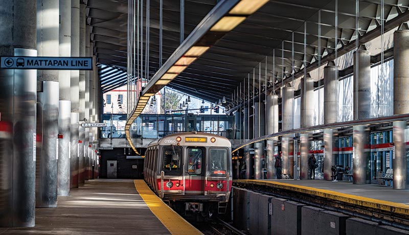
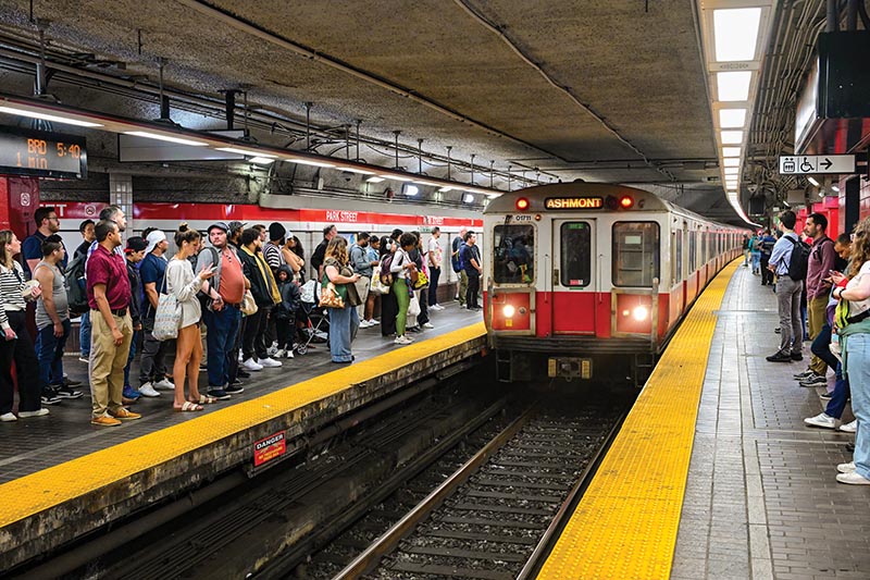
ABOVE: A Red Line train passes through the new Ashmont terminal on April 3, 2021. The rebuilt multi-modal hub hosting bus, trolley, and rapid transit opened in 2011.
The original Red Line begins in a tunnel, cut under the streets and then covered back over, in Cambridge between Kendall Square and Harvard Square. However, the subway construction was delayed as Cambridge and the Boston Transit Commission argued over the number of infill stops between the transfer-feeding station at Harvard and the city of Boston. Cambridge wanted three stops and suburban interests seeking a faster ride wanted none. The subway station at Central Square was the compromise.
As the Red Line connects Cambridge to Boston, it uses the center spans of the Longfellow Bridge to cross the Charles River, offering riders stunning views of Boston’s skyline from Beacon Hill to the Back Bay and in season, sailboats dotting the river. This bridge marks the only section of the Red Line open to the surface north of Columbia Junction in South Boston. The right-of-way for the subway was reserved during construction of the Longfellow Bridge, which was completed in 1906. When the bridge was effectively rebuilt in place 110 years later, the two subway tracks were swung back and forth on the vehicle travel lanes so the steelwork underneath could be replaced.
The subway passes through downtown Boston in a three-mile tunnel under Beacon Hill to the Park Street station, where the Red Line runs one level below the Green Line. Park Street serves as the central hub of MBTA, as arriving trains are inbound and departing trains are outbound. Connecting passages between the Red and Green lines allow transfers in four directions. The station at Downtown Crossing (formerly “Washington”) lies a block beyond Park Street in Boston’s traditional commercial district and has a connection to the Orange Line.
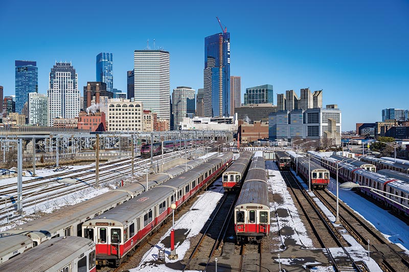
ABOVE: The Red Line’s Cabot Storage Yard and Maintenance Shop Complex in South Boston is built on a former yard purchased from the bankrupt New Haven Railroad in 1965. Located just beyond South Station, it was constructed for the South Shore extension in the late 1960s. The facility is currently the subject of a $200 million upgrade project.
When riders emerge from the Red Line at South Station, they have multiple transit options, including the MBTA Silver Line — a hybrid bus rapid transit line above the Red Line platforms that runs to Logan Airport, Chelsea, and South Boston. Farther above, up a set of stairs, is the historic headhouse for South Station, formerly used by New Haven and New York Central (Boston & Albany) trains. Beyond the big departure board are the 13 platforms shared by MBTA commuter rail and Amtrak’s Northeast Corridor trains.
Just past South Station, the Red Line drops under the Fort Point Channel to Broadway and Andrew stations in South Boston. Located at the edge of South Boston, the Broadway station has long carried passengers from the densely populated streets of South Boston into downtown, and every year moves large crowds during the annual St. Patrick’s Day and Evacuation Day parade. Near the northern end of Dorchester Avenue, numerous bus lines feed transferring passengers into the Red Line at the Andrew station.
Extending the Red Line beyond Andrew saw many different proposals, including a long cut-and-cover line down Dorchester Avenue. Instead, the purchase of New Haven Railroad’s Shawmut Branch allowed the subway to expand south into Dorchester, terminating at Ashmont in 1926, which marked the first conversion of a railroad right-of-way to a rapid transit line in Boston.
Constructed on the eastern edge of the New Haven’s former Old Colony right-of-way, the New Haven stations at Columbia, Savin Hill, Fields Corner, and Ashmont were replaced by rapid transit stations. The new extension emerges from a subway portal between Andrew and Columbia and runs south along Dorchester Bay past Savin Hill before turning west and heading inward to Dorchester. The Fields Corner station was constructed with surface line loops first used by streetcars and later by buses as a major transfer station into the rapid transit system. In 2009, the 1926 station was completely replaced by a new station with parallel bus loops on either side of the tracks. MBTA rebuilt or replaced the four stations on the Ashmont Branch between 2004 (Savin Hill) and 2012 (Ashmont). The new stations make each stop fully accessible…