
 by Victor Hand/photos by the author, courtesy Center for Railroad Photography & Art
The railroad crisis that engulfed the Northeast in the late 1960s and early 1970s was the culmination of decades of postwar economic policy that left railroads struggling with declining revenues, shifting traffic patterns, and mounting competition from government-funded highways, waterways, and aviation. In response, many carriers turned to mergers as a last-ditch solution to avoid bankruptcy. When New York Central and Pennsylvania Railroad combined in 1968 (followed by the addition of the New Haven in 1969), the resulting Penn Central instantly became one of the largest corporations in America.
Yet the 20,000-mile behemoth was fundamentally unsound, taking its first steps already off-balance. Its collapse into bankruptcy in 1970 sent shock waves throughout the region, pulling down connecting carriers and pushing the entire Northeastern rail network to the brink of shutdown. Faced with the very real prospect of losing essential rail service as the national economy entered a recession, the federal government stepped in. Congress passed the Regional Rail Reorganization Act in late 1973, and President Richard Nixon signed it into law in 1974. The “3R Act” created the United States Railway Association (USRA), charged with studying the bankrupt carriers and developing a viable plan for reorganization that would ultimately form the blueprint for Conrail.
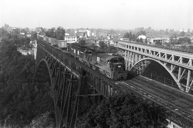
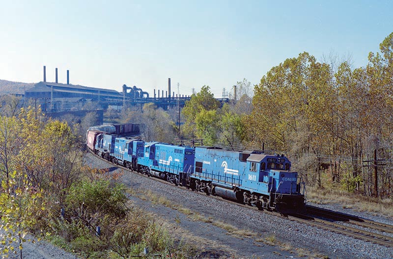
ABOVE: Six months into Conrail, Penn Central units still powered many trains. An eastbound freight crosses the Niagara River on the Michigan Central arch bridge at Suspension Bridge Station in Niagara Falls, N.Y., on October 3, 1976. The train is TV-16 from Kalamazoo, Mich., to North Bergen, N.J., combined with Train MC-4, which operated from Detroit to Selkirk (N.Y.) Yard. The MC bridge was abandoned in 2001, but the Canadian National span to the right is still used by Amtrak trains today.
Once the Final System Plan was submitted to Congress on July 26, 1975, USRA turned its attention to the property conveyance process that would be required to transfer ownership of the designated assets to Conrail and other parties. In a traditional real estate transaction, a deed is prepared describing the property to be conveyed, sometimes accompanied by a map. USRA had nine months to prepare the deeds for what was about to be one of the most complicated real estate transactions in U.S. history. The staff had assured the board of directors that there would be no “map job”; someone would look at every location out in the field where lines were being severed, and at each parcel of property that the bankruptcy trustees claimed as not “used or useful in rail transportation.”
The job seemed impossible. A proposal was made to structure the real estate transfers as a “negative conveyance.” All of the property of a transferor railroad within a given jurisdiction would be conveyed, and property to be left with the bankrupt estates would be excepted from the transfer by describing it and marking it on valuation maps. The lawyers, of course, objected that this had never been done before. After much argument, the USRA president decided that a negative conveyance was the only viable option.
Working alongside a talented group of colleagues, I was directly involved in managing the real estate conveyance process for USRA. What follows is an overview of how that work came together.
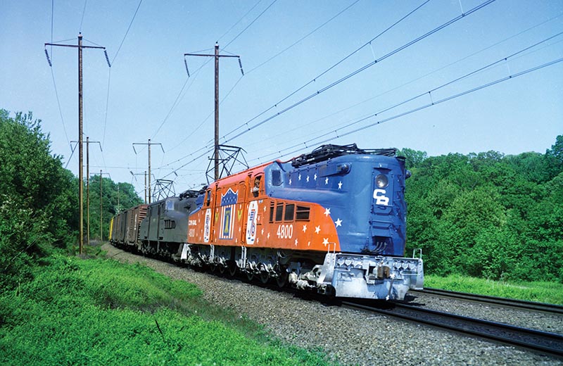
ABOVE: A westbound freight behind two E-44 electric units passes Gwynn tower in Baltimore on Amtrak’s Northeast Corridor on October 15, 1978. Conrail would end electric freight operations in 1981.
First, the bankrupt estates were asked to submit valuation maps marked with properties that they contended were not “used or useful in rail transportation,” and should not be conveyed. Valuation maps were detailed maps of railroad property and facilities that were prepared by all the steam railroads in the U.S., pursuant to the Valuation Act of 1913. Congress was considering placing a cap on railroad profits calculated as a return on invested capital. Unfortunately, there had been such financial chaos in the building of the railroad system during the 19th century that no one knew what the invested capital was. Ten years and many millions of dollars were spent in preparing these maps and cataloging and photographing railroad facilities. The process was never completed, but the maps became the basis of the property and engineering records of the railroads, and for the most part, were kept up to date as changes were made to facilities and property. These maps were invaluable in carrying out the conveyance process.
There were more than 1,250 “line cuts” where lines were being severed from the system, and more than 8,000 individual parcels of property claimed by the trustees. The USRA operating staff became property inspectors who examined all the property involved and made recommendations that were sent to USRA headquarters. The inspectors were accompanied by operating officials of the involved railroads, and often were joined by representatives of local government, major shippers, and commuter agencies.
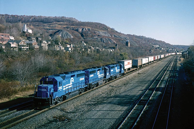
ABOVE: lue Conrail units are eastbound at Bethlehem, Pa., with Train ALOI (Allentown, Pa. –Oak Island Yard, Newark, N.J.) on October 30, 1983. In the background is Bethlehem Steel’s massive Bethlehem Works, which closed in 1995.
Each Monday, the inspectors would come to the Washington headquarters to report their findings, and to receive packages of maps for the next week’s inspections. Based on the inspector’s recommendations, the trustee’s valuation maps were either accepted, rejected, or modified. USRA had four lawyers writing deed language, four draftsmen modifying maps, and an army of clerks to keep track of all the paper.
The Penn Central trustees retained Victor Palmieri & Company, a large real estate firm, to help them with the preparation of the valuation maps, while most of the smaller estates did the work with their own real estate staff. As an aside, Palmieri had previous involvement with the company as PC quickly sold off its real estate investment subsidiary Great Southwest Corporation in 1970 when it was revealed that top executives were benefiting from fraudulent transactions and insider information (which also contributed to PC’s bankruptcy). Palmieri later became a director of Pennsylvania Company (which was owned by PC and controlled all the non-rail properties) in an effort to untangle the railroad’s obligations from its real estate holdings.
I saved a few of the more interesting field inspection trips for myself. I spent two days traveling in a hi-rail truck with Lehigh Valley’s director of real estate and operating officials. We traveled from Jersey City, N.J., to Buffalo, N.Y., inspecting properties along the way. I also performed inspections on various Erie Lackawanna and Penn Central lines.
ABOVE: Train TV-1 (Kearny, N.J., to Chicago) is westbound at South Fork, Pa., on October 29, 1985. The tracks on the right lead to South Fork Yard and the South Fork Secondary Track.
Based on the results of the inspections, deeds were prepared for each transferor and transferee in each county. There were more than 480 deeds required to carry out all the real estate transfers. The transfers of rolling stock, shop and office equipment, and inventory also required the preparation of voluminous documents. I was busy with the real estate transfers, and did not participate in this work.
For each of the more than 1,250 “line cuts” where lines were being severed, a detailed description of the exact location of the cut was required. For example, the Final System Plan might have designated the “X Branch” between milepost 0 and mile 1.2 be conveyed to Conrail. The exact location of the line cut might read “1,200 feet west of the west abutment of the bridge over Noname Creek.” This is where the field inspections proved useful, to not only determine these physical locations, but to also make sure they actually existed as they were indicated on the maps. A determination of Conrail’s need for each of the more than 8,000 individual parcels of property claimed by the trustees was made, based on the recommendations of the field inspectors and railroad operating staff. A bit of “horse trading” went on, but not much…